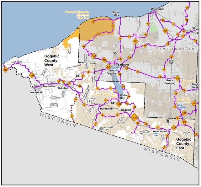
When snowmobiling gained popularity in the late 1960’s and early 70’s, groups of local sportsman started riding on the unplowed roads in the Powers Road area. As this new sport gained popularity, it was quickly realized that a need to smoothen out these trails was a necessity. Soon welders in garages and machine sheds were fired up and the first groomers were fabricated and pulled behind snowmobiles. Word got out of this new experience and locals who lived south of this Powers Road area started to clear out trails between farm fields so they could gain access to this area. These first groomers just didn’t do what was needed to maintain the trails. As luck would have it, the ski industry was also expanding and there was a need for the ski resorts to get better equipment. The first snowmobile club, Snow Drifters, was formed and equipment was purchased from the ski resorts. A little more fabricating and the new trail groomers were rolling down the trails. Quickly the trail was expanding south to Ironwood and to the east to Big Powderhorn Mountain ski resort. UP Trail 160 was blazed. People with camps along the lower Powers Road pushed a trail to Saxon Harbor. Also, people with hunting camps along the Camp 9 grade were using their snowmobiles to access their camps. While all this was going on, Niles Sandors acquired a contract with the Michigan DNR to groom trails North of Bessemer and North of Wakefield. He groomed from his residence, Alpine Campground, north to Indianhead Mountain, west to the Camp 9 grade and east to the Camp 4 grade out to Conorville. He also groomed a trail to Bingos and east to Tula. The far western trail Niles groomed was only a few miles from Big Powderhorn Mountain. With a little creativity riders could get from the Trail 160 all the way to Tula with several stops along the way. The trail system was forming. As years went on, the railroads were abandoning their rails and the rail beds were turned into trails. Now towns were getting connected and small clubs were merging into larger clubs and the Gogebic Range Trail Authority was formed. Over the years, some of the trails were closed and others were expanded or rerouted, but the one thing that is constant is the need for trail maintenance.